An indispensable companion on any journey is a high-quality navigator. And not a separate device, as before, but a trusty iPhone or iPad with navigation software installed. Our selection today is dedicated to navigators that will help you avoid getting lost, chart a route, and find a way out of any dead end. Here are 8 great navigation apps.
Let us immediately draw your attention to the fact that the selection deliberately did not include the mapping services of Apple and Google. In addition, all navigators are located in random order and are in absolutely equal conditions. You can share your preferences in the comments after reading. Go!
Navitel
Developer/Publisher : Navitel Version : 9.4.0.84
Let's start our tour of navigators for iOS with Navitel . The application has been on the App Store for a very long time and offers very high-quality navigation. Maps in the application are available on a subscription basis for many regions, including not only Russia and the CIS countries, but also Europe. They are updated frequently and contain a comprehensive number of POIs (points of interest). The main drawback of Navitel persists throughout many versions - it is a frankly unsuccessful interface. The application not only looks alien within iOS, but also makes navigation difficult due to the confusing organization of the interface. Otherwise, Navitel has everything necessary to perform its functions efficiently and is unpretentious to the presence of the Network.
iPhone + iPad : Free (+ maps purchased in app) []
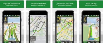
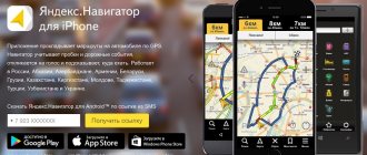
Yandex.Navigator
Developer/Publisher : Yandex LLC Version : 1.60
Next up is Yandex.Navigator . In the conditions of your hometown and a constant connection to the Internet, this is an excellent solution for navigation. High-quality Yandex maps cover many cities, clearly reflect the traffic situation and various events, receiving them from other drivers in real time. Yandex.Navigator also has voice control, as well as the ability to load maps into the device’s memory. Unfortunately, there are also a lot of unpleasant moments. The application will not warn you about speeding; multi-lane and dirt roads can also create problems for the navigator. Finally, the application is still focused specifically on a constant connection to the Internet, otherwise you will have to make too many compromises. But Yandex.Navigator is absolutely free.
iPhone + iPad : Free []
Popular navigators for iPhone
Yandex Navigator (Maps)
Distribution: free.
We recommend: Checking the Android version on your phone or tablet
The name combines the names of two services for a reason. In many ways, the functionality of the company’s two programs overlaps and is similar. The terrain layout is the same, but Navigator has extensive functionality for car drivers. The interface is close to the classic shells that are installed in specialized tablet devices. A voice assistant is used to announce the presence of a turn and the distance remaining to the arrival point. If desired, the voice can be changed in the settings. The menu contains a list of places, divided into sections with points of interest, including: restaurants, fast foods, gas stations, car washes and many other places. The Yandex Traffic Traffic service is automatically connected, showing the situation on the roads and the presence of accidents in different parts of the city. Maps can be downloaded to your phone's memory, but it is advisable to use the program with an Internet connection. This will speed up the work of geolocation and connected services.
The Maps application, in turn, is intended for use by pedestrians. There is a function to call a taxi using the location of a smartphone. This includes connecting the “Food” service. Offline maps contain all the important objects in the city and the ability to build a route. When connected, the user gets the opportunity to view bus routes, search and use synchronized services.
Navitel
Distribution: shareware.
One of the oldest navigation applications. Users of satellite navigation systems have long been familiar with the program, but now it is also available for iPhone. Has one of the best map designs on the market, but with a slight limitation. To get a high-quality map of a city or region, you will have to buy it on the official website. Developers often offer discounts, especially on regional packages. Another drawback is its interface. It has not changed much over the past few years and is not distinguished by its ergonomics and convenience.
We recommend: SHAREit on iPad
But the advantages, which are several times greater, brighten up all the disadvantages. The application contains information about the presence of vehicle speed sensors, the presence of a traffic police post, traffic lights and signs. The voice assistant warns about this in a timely manner, the sound variations of which are huge. The driver receives information about road works or dirt roads along the route. The situation on the roads is also taken into account when the driver chooses a route. To use these functions comfortably, you will need an Internet connection.
After downloading, a trial period is available, after which you need to buy paid cards.
PROTOWN
Distribution: paid.
A pleasant and functional application for use in the CIS and Europe. The distribution system is slightly different from Navitel. Here the user buys access to the application once and receives it forever, while in Navitel it is necessary to purchase each card separately. But the interface leaves one perplexed. It is not intuitive and you will have to spend a lot of time searching for some sections. One of the key features is control using voice commands. This makes it easier for the space bar with a poor interface and after some getting used to, it will be enough to launch the program and perform all other actions using your voice.
The application allows you to build a route taking into account the situation on the roads and shows the presence of speed bumps, signposts and pedestrian crossings. Also, when choosing a point of arrival, the presence of traffic jams on the road is taken into account, which the program will warn about and offer several options to choose from. An interesting technology that developers are actively distributing is “Head-Up-Display”. Using it, you can project basic information onto the windshield of a car. You just need to lift your smartphone with the screen up and the mirrored information will be shown on the windshield.
Recommended: Top 5 Keyboards for iPhone
MAPS.ME
Distribution: free.
This application is a little different from the others presented in this text. It works without the need for an Internet connection. Maps like OpenStreetMap are used as a basis, which are distributed freely. But the developers have added a huge number of labels with establishments, which significantly increases the detail of the city map. Using the program, you can directly book a room in the nearest hotel using the Booking service. The project does not have many useful functions for drivers, but is perfect for pedestrians who need to decide on their location.
On the other hand, it is still the best option for free offline maps among its competitors.
PROTOWN
Developer/Publisher : NFB Investment Version : 2.0.3295
PROGOROD is a worthy solution for navigation in Russia, the CIS countries and Europe. At the same time, to obtain unlimited access to cards you will need to pay once for a full license. The navigator regularly warns of various road objects, including speed limits and speed bumps. Driving around the city with this application is really convenient, and voice control allows you to pay less attention to the terrible interface. If you are willing to put up with it, you will get one of the best navigators in terms of building routes and guiding on the road. Good, but not perfect.
iPhone + iPad : Free (RUB 1,390) []
Briefly about the rest
TomTom
It produces excellent maps for car navigators, and many consider them the best. The same Sygic uses them. But the price is somehow not very humane. The cost of the application is 4290 rubles.
Install from AppStore
NAVIGON Russia
NAVIGON maps are used in Garmin navigators and work great in Russia, but are rarely updated.
This navigator for iPhone costs 5,290 rubles. For this money you can immediately buy a separate Garmin.
Install from AppStore
Russia - iGO
Another world-famous navigator. But the Russian hinterland here is marked not by roads, but by directions.
Price -1850 rub.
Install from AppStore
CityGuide
It’s very far from Yandex.Navigator and, moreover, it’s paid.
Install from AppStore
PROTOWN
Another domestic navigator for iPhone.
The license will cost 1,390 rubles.
Install from AppStore
NAVIGON Russia
Developer/Publisher : Garmin Version : 2.9
NAVIGON is the same good old Garmin in a new way. The application has perfect maps, excellent navigation characteristics and stands as a full-fledged standalone navigator. The Russian map alone will cost you 5,290 rubles, but the program also has in-app purchases through which you can access additional functions. Otherwise, this is exactly the navigator that experienced drivers are accustomed to. Expensive, but very high quality. Perhaps the best solution for Europe. However, for Garmin there are still blank spots on the map, for example, in Belarus. By the way, NAVIGON, for its price, can be used as a pedestrian navigator and work without connecting to the Internet.
iPhone + iPad : 5290 rub. []
Sygic Europe and Russia
A full-fledged car navigator for iPhone that uses Tom-Tom maps. It is very useful because in addition to Russia there are all maps of Europe including Belarus, Moldova, Ukraine and the entire Baltic states. If you buy these cards separately in Navitel, it will be much more expensive.
A very useful function that is available here is assistance when driving at difficult junctions.
The navigator shows the required lane to change lanes correctly. So far there is no such thing in either Yandex.Navigator or Navitel. The need for such a function in the city can be judged by one interchange on Leningradka, in the Gidroproekt area. The signs here are hung incorrectly, and out-of-town drivers have little chance of choosing the right lane without a hint from the navigator.
The cost of the application is 1490 rubles. You can additionally purchase a traffic congestion service and cameras for recording violations for 599 rubles per year.
I’ll add that this is so far the only navigator that works more or less normally with the Apple Watch and shows the nearest turn.
Install from AppStore
CityGuide
Developer/Publisher : MIT Geomatics Version : 8.2.081
CityGuide is one of the fastest applications among those discussed in this collection. It loads quickly and works quickly, supports OSM (OpenStreetMap) maps, which can replace paid analogues available for purchase from the application. In addition, for 4,290 rubles you can install HERE from Nokia in your navigator. In general, CityGuide is a decent solution that works great without an Internet connection, but with one, the application can reveal itself even better. By the way, the interface is somewhat reminiscent of Navitel and is also far from an acceptable level of comfort. For some reason, developers focus on external navigators when creating an interface rather than on the accepted standards of mobile operating systems.
iPhone + iPad : Free (maps purchased in app) []
CoPilot
Developer/Publisher : ALK Technologies Version : 9.6.2.812
CoPilot can be downloaded for free and then expanded with features and maps through in-app purchases, or you can immediately pay a tidy sum for the navigator. The application works great without access to the Internet; maps are always downloaded to the device in their entirety. The database contains many POIs, searchable via Google and Wikipedia. The main drawback of the program concerns the cards themselves. They are exclusively two-dimensional and look outdated compared to competitors, although their relevance is not in doubt. The navigator also has a convenient pedestrian mode.
iPhone + iPad : Free (maps purchased in app) []
MAPS.ME
Developer/Publisher : MY COM Version : 4.2
MAPS.ME differs significantly from the classic navigation programs that we discussed above, but this does not mean that they are worse. It's just a different kind of application. These are full-fledged offline maps based on OSM. The maps are highly detailed, the number of POIs is off the charts, a convenient search is implemented, access to the Internet is not required at all, and the application is free. Perhaps the only thing missing is the ability to plot walking routes, and there are also errors on the maps that can easily be attributed to OSM costs. We also note that the navigation capabilities behind the wheel are somewhat inferior to competitors, but from the point of view of offline operation, MAPS.ME still remains unrivaled among free products. By the way, I would also like to improve the interface.
iPhone + iPad : Free []
2 GIS
Developer/Publisher : LLC DoubleGIS Version : 3.19.3
Our selection today is completed by the 2GIS , which also has a very conditional relationship to navigation. Rather, it is an excellent directory of addresses and facilities located in your city. Moreover, the application works not only without an Internet connection, but even without GPS. However, it can provide route directions and show detailed 3D maps, which even show the number of floors for buildings. In general, 2GIS should be considered as a good collection of POIs with minimal navigation capabilities. However, this will be enough to search for a specific address or organization.
iPhone + iPad : Free []
( 9 votes, overall rating: 4.11 out of 5)