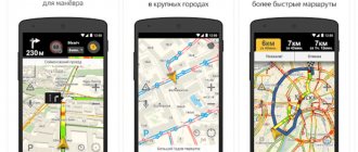
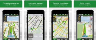
Yandex.Navigator is an application from a famous Russian company that helps motorists find the right route to reach a certain point on the map. Of course, it depends on the Internet, but it is not so important for the proper functioning of the program. For example, you can download maps for Yandex Navigator for Android in advance, so that you can later use the software without access to the Internet. How to do this will be discussed further in the text.
What are offline maps for a navigator?
First, let’s look at the very concept of “offline cards” – what they are and what they are needed for. Any navigator on an Android mobile device works as follows: it loads a map of the area, then determines the user’s location in space and puts a mark in the appropriate place, which directly symbolizes the user’s location. It is noteworthy that the Internet is needed only to complete one item from the list - downloading a map. Therefore, in order to use Yandex.Navigator without access to the Internet, you need to download an offline map in advance.
How to upload maps to the application
Now let's move on directly to how to download an offline map to your phone and install it in the Yandex.Navigator program. This action is quite simple and does not require special knowledge from the average user. You need to do the following:
- Launch the application and open the menu. To do this, you need to click on the function button, which is displayed in the form of three horizontal lines.
- In the list that appears, click on the “Download maps” item.
- Use the search to find your city or region.
- Opposite the desired location, click “Download”.
If everything is done correctly and meets the necessary requirements, then soon the map of the selected region will be downloaded to your phone and can be used offline.
What to do if the card you need is not on the list
It may also happen that the required map is not in the list, or for some reason it refuses to load. Then you should contact the feedback center:
- Go to the support page.
- Expand the form by clicking on the “Feedback” line.
- In the appropriate fields, enter your name and email to which the response will be sent.
- In the “Message Subject” item, select “Technical Problem”.
- In the “Message” field, describe your problem, send a screenshot if necessary.
- Click the "Submit" button.
Selecting online/offline maps for Android devices: Yandex.Maps, Google Maps and 2GIS
Table of contents
- Introduction
- Yandex. Cards
- Acquaintance
- Settings
- Testing
- Intermediate output
- Acquaintance
- Settings
- Testing
- Intermediate output
- Acquaintance
- Settings
- Testing
- Intermediate output
Introduction
This time we will talk about navigation, or more precisely about offline and online maps.
If not everyone, then most users know how to use them. We are interested in their gluttony, stability, ease of control and positioning accuracy, although the latter parameter is more dependent on the GPS module of the mobile device. Using the example of a single city, we will find out how accurately the information is displayed and whether it corresponds to reality, and also check the operation of the applications and see what functions they have. Let’s make a reservation right away that car navigation will not be taken into account, but if most users want to see such a review, then we are waiting for your wishes.
In addition, we will not cover the entire range of such programs, having considered only a few of the most popular ones, as well as those that are not used often, but are equipped with interesting functions. And, as is tradition, we will test applications that are “not for everyone.”
But let's start with the most popular - Yandex.Maps, Google Maps and 2GIS maps. One can understand the irony of some users, because this is also the most obvious (and the last participant is a completely offline map), but sometimes you want to compare the incomparable.
The test equipment used was a DEXP Ursus 8EV2 3G tablet (Android 4.4.2, MT8382 processor, 4 x 1300 MHz, 1 GB RAM).
announcements and advertising
2080 Super Gigabyte Gaming OC for 60 rubles.
Compeo.ru - the right comp store without any tricks
RTX 2060 becomes cheaper before the arrival of 3xxx
Ryzen 4000
series included in computers already in Citylink
The price of MSI RTX 2070 has collapsed after the announcement of RTX 3xxx
Core i9 10 series is half the price of the same 9 series
The price of memory has been halved in Regard - it’s more expensive everywhere
Yandex. Cards
Acquaintance
“Yandex.Maps show detailed maps of most cities and countries of the world, provide detailed background information about organizations in the city, build routes by car and by public transport to avoid traffic jams. Maps of more than 200 cities can be used offline.”
In principle, the developer's explanation is more than enough. Okay, let's get started.
| Rating on Google Play (free/paid versions) | 4.3 |
| Compatibility of the application with other versions of Android OS | 2.3 or later |
| Distribution size | 13 MB |
| Application version | 3.81 |
| In-app purchases | — |
Main functions:
- Detailed maps of the whole world, which are updated regularly;
- Satellite images and street panoramas help to navigate the area;
- Offline maps of cities in Russia, Ukraine and Belarus;
- Search for addresses, as well as cafes, pharmacies, ATMs, gas stations and other things;
- A convenient catalog for selecting organizations and detailed information about them: operating hours, telephone, rating, list of services, etc.;
- Voice search to navigate maps on the go or while driving;
- Bookmarks to save your favorite places;
- Real-time information about traffic jams, accidents, road works, speed radars, etc.;
- Car routes taking into account traffic jams;
- Public transport routes indicating all transfers.
Permissions:
Identification data:
- Search for accounts on the device;
- Adding/removing accounts.
Location:
- Accurate location (based on network and GPS signals);
- Approximate location (network based).
Photos/multimedia/files:
- Changing/deleting data on a USB drive;
- View data on a USB drive.
Microphone:
- Audio recording.
Wi-Fi connection information:
- View Wi-Fi connections.
Device ID and call data:
- Receiving information about the phone status.
Other:
- Direct installation of applications;
- Unlimited Internet access;
- View network connections;
- Connecting/disconnecting a Wi-Fi network;
- Changing system settings;
- Using accounts on the device;
- Creating accounts and setting passwords;
- Vibrate function control.
| Ease of control and navigation | Great |
| Possibility of self-configuration | Great |
| Interface | Great |
| Maximum system load (CPU/RAM) | 0/25-70 MB |
| Functionality | Fine |
| Map rendering | Average |
| The location is true to reality | Average |
| Territory coverage | Great |
| Working with offline maps | Great |
Settings
Let's start with the settings. Here, in addition to the fact that we are offered to download a map, view bookmarks, etc., there is another interesting item - communication monitoring. But first things first.
If everything is clear with bookmarks, then downloading an offline map deserves attention. In addition to basic maps of the nearest cities, there are also popular maps, that is, it is proposed to download the “terrain” that is as close as possible to you.
Quite a good solution, because if you take the same 2GIS, then everything is limited by the database of cities that the developer has.
Communication monitoring does not show signal strength or nearby towers, as we initially thought, but simply replaces “Complain about communication quality and leave a comment.”
There are also additional settings. Here, in addition to warnings about cameras, automatic map rebuilding when moving, you can enable display of the map in HD resolution (not for all cities) and activate perspective display.
Well, we figured out the basic parameters.
Testing
Let's start with the appetites of Yandex.Maps. When first launched, the program consumed 25.1 MB of RAM, which was pleasing, but after 40 minutes this figure increased to 70 MB. I very much doubt that this is the limit, although this is not surprising, since the very point of the program is to load data.
As for the distribution, the original 13 MB turned into a weighty 72 MB. Of course, we downloaded a 16 MB offline map of a small town, but this still does not cover the final size.
In the case of permissions, there is no point in considering each one, since the program climbs everywhere it can, but this is Yandex, how can you not “trust” it. IT companies need metadata, as without them in our time (especially since we allow them ourselves, otherwise we don’t install them).
Let's start by drawing maps. Let's face it, she's not one of the best, although it's all about the satellite, not the program. The urgency of traffic jams is quite tolerable if you rely on your own experience. House numbers are present, as well as other periphery, such as cafes and other things, but these are only the “most famous places” and nothing more. Apparently there is no HD display for Novosibirsk.
As for remote places, everything is more or less normal here. Although there are no house numbers, street names and significant buildings are indicated.
With “layers” everything is standard: diagram, satellite, “people's” map. The latter can be supplemented with road events, which we comment on.
As for the search, there are all possible services, but Yandex was not at all surprised by this, just as it was not surprised by the method of laying out routes - by car or by public transport.
Let's finish this review with ease of control. Looking ahead, let's say that Google has much fewer function keys, which corresponds to the modern appearance of the application, but with the “classic” Yandex it is much easier to manage the program. Everything is intuitive and you can figure it out literally right away.
Intermediate output
You can’t find fault with Yandex.Maps regarding resource consumption, unfinished interface or ease of navigation. This is all right here.
But the developers need to be held accountable for the inaccuracy of the data provided, since they decided to rely on the experience and knowledge of users (when creating a people's map) rather than implement it themselves. Yes, there is a definite advantage in this approach, because even 2GIS does not have the same data about unfamiliar areas that Yandex has, but the “reconnaissance” of these territories is completely entrusted to the users.
There is only one conclusion - the search giant decided not to bother with cartography, making the “Map” completely open, and then, as they say, they themselves.
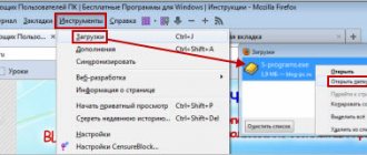
How to save cards to a flash drive
If offline maps do not load due to insufficient memory, then you can download them to a USB flash drive. To do this, follow these steps:
- Launch Yandex Navigator and open the menu.
- Go to settings by clicking on the item of the same name.
- Open the Advanced Settings section and then enter Saved Data.
- Click on the “Card Folder” button.
- In the file manager, select the folder into which they will be downloaded.
How to set up automatic map updates
Yandex.Navigator is constantly improving, so maps can be updated. In order not to miss a new release, you can set up automatic updates. This is done directly in the application itself and does not take much time. Here's what you need to do:
- Open the program and enter its menu.
- Go to Settings and then select Advanced Settings.
- Proceed to the “Map and Interface” section.
- Click on the line “Update maps”.
After that, you just need to select the desired option. So, if you select “Only via Wi-Fi”, the update will start downloading only when connected to a wireless Network. If you select “Automatically”, the download will occur whenever you connect.
MAPS.ME
A program familiar to many with OSM-based maps, which use a fairly effective vector data compression algorithm. For example, the entire Russian Federation “weighs” about 2 GB, and the picture turns out monotonous, monotonous, but not at the expense of detail.
RAM consumes a lot (about 200M with an HD screen).
He can't write tracks! (let me remind you that recording a track in the application is not important to me - I use a logger)
Possibilities:
- offline construction of routes (including bicycle routes) between two given points with the possibility of subsequently adding intermediate points (“drop in”);
- offline search for objects (POI, points of interest), including by category;
- Export/import of bookmarks (tags, waypoints) and import of tracks (routes) in KML/KMZ format;
- detailed information about establishments on the map;
- booking hotels through Booking.com;
- editing OSM objects directly from the application.
Advantages: ease of learning, speed of operation, low weight of cards.
Flaws:
- intrusive advertising that appears in the notification shade completely suddenly, even if the program (more precisely, its visible part) is not running. However, on 4pda there are versions from folk craftsmen that are free of this disadvantage;
- there is no grouping of regions of the Russian Federation by federation. districts. You can download regions separately or the entire Russian Federation at once;
- the map is designed for road and urban tourism and is far from topographical (relief, type of vegetation, etc. are not shown);
- You cannot place intermediate points BEFORE building a route - you can only adjust the route by adding points one at a time. (for example, I often just need to measure the distance along an already known path)
In general, MAPS.ME is quite suitable for unassuming tourists.